
Good forests start with good maps
Why do we need good maps?
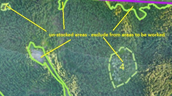
Here is one example:
A client did not have accurate maps, prior to their forest requiring thinning. We flew over the area with a drone and stitched the images together to get a geo-referenced aerial map. The aerial map was digitised in a Geographic Information System (GIS) delineating the forest boundaries as well as the gaps which were not stocked with trees. This then gave us a net stocked area. The total title areas added up to 106.1 hectares. The mapped net stocked area was 89.6 hectares. Pine was planted to fully utilise title area. Contractors quote and get paid based on an agreed value per hectare. Had we not accurately mapped the area and removed the gaps where there were no trees, the forest owner may have paid the value of 16.5 ha too much, or at best made a guess of how much area was taken up by roads, tracks, rivers, indigenous vegetation and other gaps in the planted areas.
The mapping job cost the equivalent of between 1 and 2 hectares of thinning, and the benefits are there for future operations as well (preliminary yield estimates, inventory plot establishment …).
Thinning pre-assessment
Leading on from accurate mapping, thinning pre-assessment established that the crop was standing quite light (fewer trees per hectare than what is normally encountered in that region) and therefore the cost per hectare would be lower. The eventual rate agreed on was approximately 30% cheaper than a fully stocked forest would have cost. Had pre-assessment not been done, the forest owner would probably have paid a lot more than necessary to thin the forest. The cost of pre-assessment was about the cost of 2 hectares of thinning. If recent imagery is obtained via drone mapping, an indication of stocking can be obtained to plan plot locations and sizes as well.
This example can be considered as the extreme end of things, but most, if not all, operations will benefit from accurate mapping and operational pre-assessment/ planning.
Thinning pre-assessment can also provide some preliminary growth data and enable some analysis around thinning prescriptions and ultimate impacts on harvest timing and yields.
Another upside is that good quality pre-assessment data, combined with accurate mapping, provides confidence to contractors, so they don’t feel the need to add “fudge factors” to pricing.